شش نقشه از طهران و حومه در عهد قاجار (۱۸۴۸ تا ۱۹۲۵ میلادی).
قدیمیترین نقشه ی طهران، دوران فتحعلی شاه قاجار (۱۸۲۶ میلادی)
آفریننده: ناسکوف، افسر ارتش روسیه. تاریخ خلق نقشه: ۱۸۲۶ میلادی (۱۲۰۵ خورشیدی) – منبع: کتاب اسنادِ تصویری شهرهای ایران. محمد مهریار و همکاران. تهران، دانشگاه شهید بهشتی، ۱۳۷۸ش. صفحه ۱۴۷٫ به نقل از نیمروز

نقشه ی دوم طهران، دوران محمد شاه قاجار (۱۸۴۸ میلادی)
خالق نقشه: الیاس برهزین – تاریخ خلق نقشه: ۱۲۲۷ خورشیدی (۱۸۴۸ میلادی) – منبع: نیمروز

نقشه ی سوم طهران، دوران ناصرالدین شاه قاجار (۱۸۵۸ میلادی)
خالق اثر: آگوست کرشیش – تاریخ چاپ: جمادیالاولی ۱۲۷۵ هجری قمری (۱۸۵۸ میلادی، ۱۲۳۷ خورشیدی) – منبع: نیمروز

نقشه ی طهران، دوران ناصرالدین شاه قاجار (۱۸۹۱ میلادی)
خالق اثر: عبدالغفار خان نجمالملک – تاریخ چاپ: محرم ۱۳۰۹ هجری قمری (۱۸۹۱ میلادی، ۱۲۷۰ خورشیدی) – منبع: نیمروز

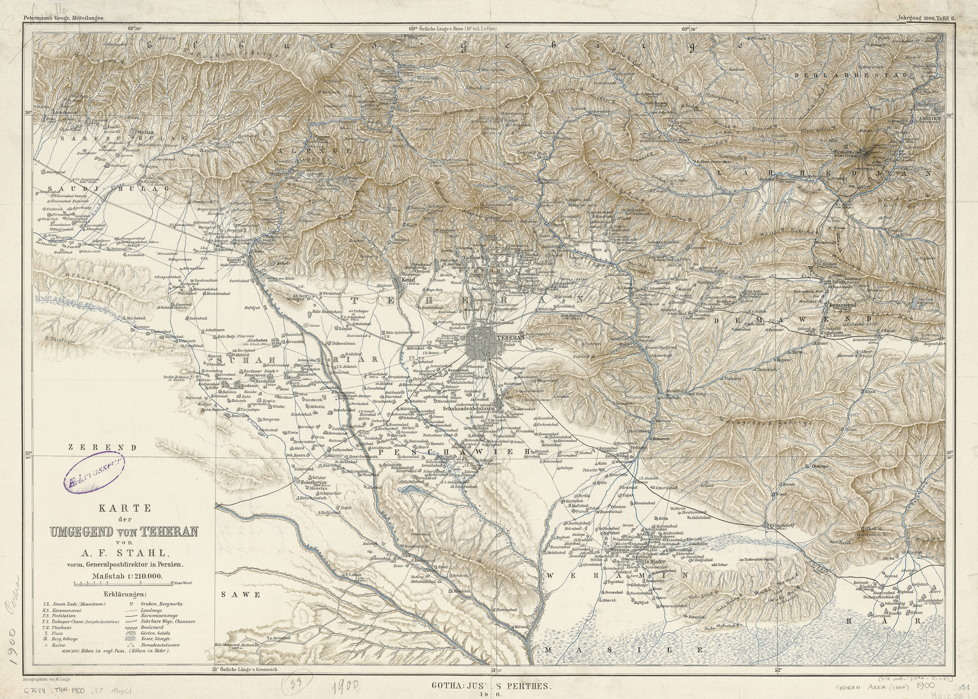
نقشه ی طهران و حومه، دوران مظفرالدین شاه قاجار (۱۹۰۰ میلادی)
خالق نقشه: آلکساندر فردریش اشتال – تاریخ خلق نقشه: ۱۹۰۰ میلادی (۱۲۷۹ خورشیدی) – منبع: نیمروز
نقشه ی موقعیت مدارس ملی طهران در دوران احمد شاه قاجار در فاصله سال های ۱۹۲۰ تا ۱۹۲۵ میلادی
ترسیم اداره تفتیش وزارت معارف، تاریخ: پس از ۱۲۹۹ و پیش از تاریخ ۱۳۰۴ (سال های میان کودتای سید ضیاء طباطبایی و سقوط قاجاریه) – منبع: نیمروز

✤ Also available in: English
سلام در حال حاضر که فعالیت سایتنیمروز متوقف شده چگونه میتوان به ایننقشه ها دسترسی داشت؟
متاسفانه نتونستم سایت نیمروز رابا این مضمون پیدا کنم لطف کنین آدرسشو بنویسین.
به نظر می آید که فعالیت سایت نیمروز متوقف شده است.
Great selection, but the last name of the Czech author of the third map is misspelt: Křziž
Thank you. The spelling is corrected now.
درود فراوان
خواستم نکته ای رو گفته باشم
نوشتن طهران درست نیست
تهران درسته
ما در الفبای فارسی ط نداریم
ط از الفبای عربی وارد الفبای فارسی شد
ث.ح.ذ.ص.ض.ظ.ع.ط.ق
اینها در الفبای فارسی وجود نداشته است
البت کلماتی هست همچون ذانستن که امروزه دانستن نوشته میشود
و گنبذ که گنبد نوشته میشود
از کلماتی هست که ذ دارد و فارسی هستند
ص =صندلی که درست ان چندل میباشد
و بسیاری دیگر
علت استفاده از کلمه ی «طهران» این است که این نقشه ها مربوط به دوران قاجارند و روی خود نقشه ها نام شهر به صورت «طهران» آمده.
در مورد حرف «ط» باید بگوییم که حرف «ط» از حروف فارسی است و جزو الفبای فارسی هم هست. بقیه حروفی هم که ذکر کردید جزو الفبای فارسی است و در لهجه های مختلف فارسی تعدادی از این حروف بیانگر صداهایی هستند که در فارسی استاندارد وجود ندارند. مثلا حرف «ق» در فارسی تهران همانند «غ» تلفظ می شود ولی در کردستان یا در بسیاری شهرستانهای جنوب کشور (مثلا فسا) تلفظی متفاوت دارد. تعدادی از این حروف در زبان فارسی دوران پیش از اسلام هم تلفظ می شده اند.
سلام با تشکر از این نقشه های ارزشمند.من برای یه پروژه و تهیه ی پاورپوینت راجع به میدان اعدام نیاز به این نقشه ها باکیفیت بالا دارم.اگر اجازه بدین میخواستم امکان سیو کردن آنها رو داشته باشم البته با ذکر منبع.منتظر پاسختون هستم.با تشکر
منبع را در ابتدای پست آورده ایم. لطفا با منبع نقشه ها، سایت نیمروز، تماس بگیرید.
یاد اون روزها بخیر صداقت و صمیمیت موج میزد
Note that the second and third map on this site are not from Mohmmad Shah but from his son, Nasseredin Shah, as per the title bar on each map.
Please correct the captions.
سلام
اگه امکان ارسال متن خبرتون از طریق ایمیل بود خیلی عالی میشد
موفق باشید
خواننده ی گرامی، این امکان وجود دارد. در این باره هم زیر یک یک پست ها نوشته ایم و لینک داده ایم و هم در بالای ستون دست چپ و همین طور در پایین هر صفحه لینکی را با تصویر پاکت نامه مشخص کرده ایم.